
The Battle Royale Island is the main battle arena of Battle Royale. It consists of a 10x10 grid with many major named locations and unnamed POIs (points of interest). Each Season, new map locations or areas are introduced or removed. Sometimes Patches change the map in some way, such as the building in Tilted Towers being built.
Interactive Map
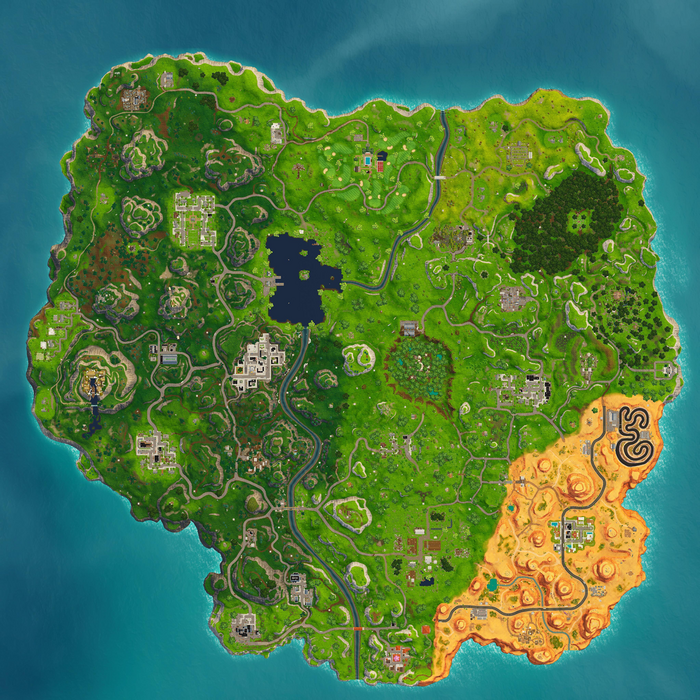

* Please note that the visual of this map is as per Patch 5.40. Any changes on the map will be documented on pages per coordinates.
Points of Interest
POIs (points of interest) are notable locations on the Battle Royale Island, ranging from specific named places and sites to smaller settlements. The current version of the map has the following points of interest:
Junk Junction
Junk Junction is located at the northwestern corner of the map at coordinates B1-B2, north of Haunted Hills. It is a wrecking yard with heavy equipment and piles of scrap metal and compacted cars.
Lazy Links
Lazy Links is located at the northern part of the map at coordinates F2-F3, west of Risky Reels. It is a recreational sports club with a swimming pool, volley ball court, a golf course and other amenities. Lazy Links replaced the previous location, Anarchy Acres, in Season 5.
Risky Reels
Risky Reels is located at the northeastern corner of the map at coordinates H2, east of Lazy Links and northwest of Wailing Woods. It is a drive-in movie theater with two houses, the other holding the projector. The movie screen was broken by a meteor fragment but it's now fixed.
Haunted Hills
Haunted Hills is located at the northwestern corner of the map at coordinates B2, south of Junk Junction and northwest of Pleasant Park. It is a cemetery with sheds, tombstones and a church.
Pleasant Park
Pleasant Park is located at the northwestern part of the map at coordinates C3-C4, between Haunted Hills and Loot Lake. It is a suburban residential neighborhood with houses and an open soccer pitch.
Tomato Temple
Tomato Temple is located at the northeastern part of the map at coordinates G3-G4, north of Dusty Divot and west of Wailing Woods. Tomato Temple replaced the previous location, Tomato Town, when the Rift teleported the temple from the past in midway Season 5.
Wailing Woods
Wailing Woods is located at the northeastern part of the map at coordinates H3-H3, I4-I4, north of Lonely Lodge and east of Tomato Temple. It is a forested area with wooden sheds, a bunker and a hedge maze in the center.
Snobby Shores
Snobby Shores is located at the western part of the map at coordinates A5, northwest of Greasy Grove and southwest of Pleasant Park. It is a neighborhood on the shore with luxury houses and villa.
Dusty Divot
Dusty Divot is located at the center of the map at coordinates F5-F6, G5-G6, north of Salty Springs and west of Retail Row. There was once an active facility in the center of the crater which studied the meteor. Now it's abandoned and overgrown. The remains of Dusty Depot's warehouses are still standing at the outer rim of the crater. The remains have been converted into Dusty Diner, complete with a gift shop, a dining area, and relics exhibiting what happened to cause Dusty Divot. Dusty Divot destroyed half of Dusty Depot in Season 4 when the Meteor hit.
Retail Row
Retail Row is located at the eastern part of the map at coordinates H6, east of Dusty Divot and north of Paradise Palms. It is a store complex with a wide parking lot complete with a small neighborhood.
Lonely Lodge
Lonely Lodge is located at the eastern part of the map at coordinates I5-I6, J5-J6, south of Wailing Woods and east of Retail Row. It is a location with many lodges in a forested area with flowing water, steep cliffs, woodsheds and a high watchtower.
Salty Springs
Salty Springs is located at the southern part of the map at coordinates F7, west of Shifty Shafts and south of Dusty Divot. It is residential area with houses and a gas station. The blue house also has a secret bunker built for the heroes.
Tilted Towers
Tilted Towers is located at the western part of the map at coordinates D5-D6, between Loot Lake and Shifty Shafts. It is a city with many high buildings, vehicles and is the largest and most popular area on the Battle Royale Island.
Greasy Grove
Greasy Grove is located at the southwestern corner of the map at coordinates B7-C7, west of Shifty Shafts and southwest of Tilted Towers. It is a residential neighborhood with a fast food restaurant, Durrr Burger, a gas station and a camping store.
Shifty Shafts
Shifty Shafts is located at the southwestern part of the map at coordinates D7, east of Greasy Grove and south of Tilted Towers. It is an underground mineshaft with minecarts, buildings and trucks.
Fatal Fields
Fatal Fields is located at the southern part of the map at coordinates F8-F9, G8-G9, north of Lucky Landing and west of Paradise Palms. It is a farm with barns, a stable, corn fields, ponds and a white farmhouse in the middle.
Paradise Palms
Paradise Palms is located at the southeastern corner of the map at coordinates H8-I8, east of Fatal Fields. It is a small city with a hotel and three stores. Paradise Palms is covered entirely in desert. Paradise Palms replaced the previous location, Moisty Mire, in Season 5.
Flush Factory
Flush Factory is located at the southern corner of the map at coordinates D9, west of Lucky Landing and south of Shifty Shafts. It is a large factory that manufactures toilets with warehouses and machinery.
Lucky Landing
Lucky Landing is located at the southern part of the map at coordinates F10, east of Flush Factory, and south of Fatal Fields. It is town with traditional Asian-inspired houses with thatched roofs, shrines and a pink cherry blossom tree centerpiece.
Unnamed POIs
- Motel
- Stadium
- Villain Lair
- Container Yard
- Race Track
- RV Park
- Mansion
- Viking Outpost
- Warehouses
- Adobe Village
- Loot Lake
- Castle
- Floating Island
* All unnamed POIs listed have more than 3 structures, fixed floor loot spawns and more than 3 chests. Smaller POIs such as single houses and buildings are documented on their grid coordinates.
Limited Time POIs
- Shrines
- Moai Heads
Limited Time Challenges Props
- Film Cameras
- Birthday Cake
Interactable Map Objects
- Basketball Hoops
- Golf Course
- Skeet Shooters
Former POIs
Dead Grid
The following coordinates are considered as dead grids that are unexplorable and covered with water: A1, E1, F1, G1, H1, I1, J1, A2, J2, J3, A3, A7, A8, B8, A9, B9, C9, J9, A10, B10, C10, I10 and J10.
Map Markers
Map History
- Season 5 Battle Royale Map v5.40
- Tomato Temple replaced Tomato Town.
- Season 5 Battle Royale Map v5.0
- A desert biome has been added.
- Paradise Palms has replaced Moisty Mire.
- Lazy Links has replaced Anarchy Acres.
- Viking Outpost, Adobe Village have been added. The Dirt Track POI has been upgraded to the Race Track.
- The Open Soccer Stadium was removed.
- Season 4 Battle Royale Map v4.0
- Dusty Depot was destroyed and renamed to Dusty Divot.
- Risky Reels was added to the map.
- Unnamed POIs; Mansion and Villain Lair were added.
- Dusty Divot occupied the Factory's former location.
- Castle Ruins were replaced with an Open Soccer Stadium POI.
- Season 3 Battle Royale Map
- Lucky Landing was added.
- Season 2 Battle Royale Map
- Map Grid count and coordinates have been changed.
- Tilted Towers, Shifty Shafts, Junk Junction, Haunted Hills and Snobby Shores were added.
- Unnamed POIs: Stadium, Warehouses, Castle Ruins and Motel were added.
- Season 1 Battle Royale Map
- Initial launched map consists of Greasy Grove, Pleasant Park, Retail Row, Anarchy Acres, Fatal Fields, Lonely Lodge, Flush Factory, Loot Lake, Moisty Mire, Wailing Woods and few unnamed POIs; the Container Yard, Prison, Factory, Dirt Track and RV Park.
- Formerly unnamed POIs; Salty Springs, Tomato Town and Dusty Depot have been eventually named.
Changes
- Bug Fixes
- Player placed map markers will no longer appear to jitter on the minimap or in the world.
5.10 Patch Update (July 24, 2018)
- Audio
- Added specialization to the sound played when a marker is placed on the map. Now you will hear it coming from where the in-world marker was placed.